A change in ECMWF’s seasonal prediction system, SEAS5, has reduced the underprediction of tropical storms seen for the last few years.

ECMWF’s Frédéric Vitart (left), principal scientist, had a key role in developing it. After studying applied mathematics in the 1990s, his PhD was on using a seasonal model for tropical cyclone predictions at the University of Princeton, USA.
He joined ECMWF in 1998, and since 2004 he has overseen extended-range forecasts, up to 46 days ahead. But he continued to work on forecasts of tropical storms in the seasonal prediction system.
The problem
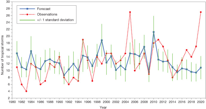
Until relatively recently, ECMWF seasonal forecasts of tropical storms showed significant skill over the Atlantic up to seven months ahead. But since 2016, the model has strongly underestimated the number of tropical storms and accumulated cyclone energy (ACE) in the Atlantic basin.
“Alarm bells rang when SEAS5 starting on May 1, 2020 predicted only 11 tropical storms between June and November, while 27 were observed,” Frédéric notes.
As the chart below shows, the number of tropical storms has, on average, gradually gone up over the years, while the predictions provided by ECMWF’s seasonal system have not.

The reasons behind the inconsistency between the model and the observed tropical storm trend over the Atlantic is currently under investigation. In the meantime, it was appropriate to think about a change in calibration.
The solution
In the previous system, the calibration was performed by comparing the observed and predicted number of tropical storms over the fixed period 1993–2016.
The ratio between the number of observed and predicted tropical storms computed over that period was then used to multiply the predicted number of tropical storms in subsequent years.
“An issue with this method is that the biases during the period 1993–2016 are not representative of the model biases since 2016, because of the difference in trends between SEAS5 and observations,” explains Frédéric.
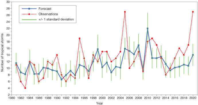
The new method consists of computing the calibration coefficient over a 10-year running period preceding the year of the forecast. For instance, the 2020 forecast is calibrated using the period 2010–2019 instead of using the fixed period 1993–2016.

It is found that the new calibration is a better simulation of the observed trend. “While it does not solve the 2020 seasonal forecast bust, it slightly reduces the difference,” Frédéric explains.
The forecast for 2020 is now of 14 tropical storms, which is slightly above an average season. Previously it was just 11, which is below an average season. And there is an upward trend in the forecast from 1980 similar to the trend in observations.
This change has only been applied in the northern hemisphere because in the southern hemisphere the shorter calibration period produced too much noise.
The new calibration system has been implemented by ECMWF’s head of seasonal forecasts, Tim Stockdale, and is now operational.
Work on the extended range
In addition to overseeing tropical cyclones in seasonal forecasts, Frédéric is ECMWF’s head of extended-range forecasts. Over the last year, he has been busy designing a new configuration for extended-range forecasts to be implemented on the new ECMWF supercomputer in Bologna, Italy.
In terms of research, he has been working on the representation of teleconnections between the tropics and the extratropics. These are currently too weak in the model.
“We are looking at errors in the impact of the jet stream on teleconnections,” Frédéric says. “We try to understand where the errors come from and if we can fix them.”
The efforts come after his team showed that teleconnections of the tropical Madden–Julian Oscillation (MJO) become weaker as lead time increases, suggesting that systematic model errors could be responsible.
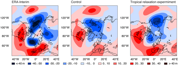
To obtain more details, they produced a set of 15-member re-forecasts, using Cycle 45r1 of the Integrated Forecasting System, over the period 1989–2016.
In some of these re-forecasts, the tropics were relaxed towards the ERA-Interim reanalysis, producing ‘perfect’ forecasts of the tropical circulation, including the MJO. In others (the Control) they were left untouched.

The figure shows that MJO teleconnections are significantly weaker in the relaxation experiment than in ERA-Interim, and not significantly stronger than in the Control experiment.
“This result suggests that the origin of this problem is not in the tropics but most likely originates from systematic errors in the extratropics,” Frédéric notes.
S2S work
Frédéric is also the co-chair, with Andrew Robertson (IRI, USA), of the Steering Group of the Sub-seasonal to Seasonal (S2S) Prediction Project.
The S2S project is intended to improve forecast skill and to widen the uptake of S2S forecasts. It was started in 2013 by the World Climate Research Programme and the World Weather Research Programme.
“We have a database to stimulate research and we are launching an artificial intelligence challenge,” Frédéric explains. “This is an important part of my work, which goes beyond the boundaries of ECMWF.”


