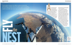


The key players involved in the WMO’s recently concluded UAS Demonstration Campaign discuss the project’s success and explore the main challenges that need to be overcome before uncrewed aerial systems can provide wide-scale, routine and real-time observations.
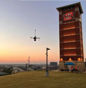
Are uncrewed aerial systems (UAS) ready to provide real-time observations to the weather models that inform operational forecasts? The World Meteorological Organization set about answering this question with its UAS Demonstration Campaign (UAS-DC), collecting observations from some 50 drone operators worldwide from March to September 2024. “We’ve had 12,000 atmospheric profiles uploaded so far, primarily from the US and Europe but also from Japan and Taiwan,” says US National Science Foundation Center for Atmospheric Research (NCAR) scientist and project leader Dr James Pinto. “Some private operators provided UAS observations to modeling centers within an hour of collection.”
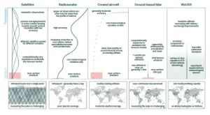
Drones could plug observation gaps in the lower atmosphere, especially where meteorological services are sparsely funded. Studies have shown that UAS can collect insitu data of accuracy comparable to that of radiosondes, potentially at lower cost with less environmental impact thanks to their reusability. However, regulatory approval and limitations in windy or icing conditions present key impediments. “Currently, drones are used for research,” says Dr Debbie O’Sullivan, remote sensing and airborne observations science manager at the UK Met Office. “They can measure air pollution and chemistry, or even observe conditions within a hurricane’s eyewall. What’s new here is doing it routinely and providing observations in real time.”
The UAS-DC is animated by reciprocity of benefits. “The WMO sets the tone for the industry,” says Menapia’s chief meteorological officer, Dr Ben Pickering. “When it decides to examine the feasibility of UAS systems, that’s really significant.” Because operators stand to benefit from a WMO report endorsing their technology, the organization can leverage their assets and know-how on a self-funding basis.
Data-gathering UAS
Basic temperature, humidity, pressure, wind and altitude measurements were collected by academic, private and government operators for the WMO campaign. The most advanced commercial weather-sensing UAS were typically multirotor aircraft. Meteomatics delivered data in real time from a completely autonomous system in Switzerland, while observations from more experimental aircraft sometimes took longer to upload.
Fixed-wing systems were launched from catapults, ramps and vehicles or simply thrown, like paper airplanes. “We had all sizes, from long-range balloon-borne systems to palm-sized microdrones,” says Pinto. Systems combined rotors for vertical take-off with wings to provide range aloft. High-altitude platforms attained the stratosphere using balloons or solar power.
Delivery drones also provided observations of opportunity. Notably, Zipline contributed the most US observations, albeit only measuring winds below 120m. “It creates an analogy with commercial aircraft-based observations,” says Pinto. “As delivery drones proliferate, they may provide widespread, low-level observations useful in improving forecasts.”
The seven-month project included special operations periods (SOPs) promoting simultaneous participation, the first two coinciding with the total solar eclipse and the Paris Olympics. The International Society for Atmospheric Research using Remotely-piloted Aircraft (ISARRA) organized the final SOP in Tulsa, Oklahoma, in September 2024. “We used SOPs to maximize coverage, since the greatest impact on forecasts will come from widely distributed networks,” says Pinto.
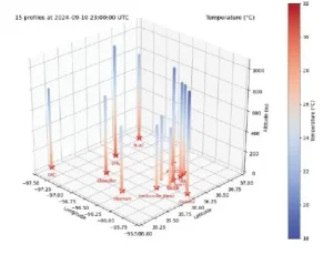
“In Tulsa, profiling UAS augmented a subset of surface stations across an area twice the size of Connecticut in the first-ever 3D mesonet demonstration,” he continues. “Such augmented networks can better capture atmospheric features important to predicting severe weather.”
Standardization efforts
Beyond accuracy and robustness, operational feasibility means producing data in a format numerical weather prediction (NWP) models can readily ingest. “We needed that critical piece in place before the flight campaign,” says O’Sullivan, who led the standardization effort. “NetCDF is most commonly used by UAS operators, whereas binary BUFR files containing data in small packets are what models ingest.”
WMO task teams first created a standard netCDF template for UAS measurements, then a code to convert them to BUFR format. Though many operators already used netCDF, the methods by which variables were calculated, files structured and metadata attached varied considerably. “Just getting agreement on what we meant by turbulence, how to measure it then convert that to the BUFR version took months of work,” explains O’Sullivan.
12,000+ atmospheric profiles were collected as part of the WMO UAS demonstration campaign
The WMO worked assiduously to ensure that operators implemented the new format correctly. “Unless every character complies, it won’t work,” says Pickering. “The BUFR converter helped. If a file didn’t translate, we knew it wasn’t correct, but then had to comb through manually looking for errors, such as a missing ‘t’ between the date and time in the file name.”
This labor fructified in one model-ingestible format common to all operators. “The UAS-DC has pushed everyone onto the same pipeline,” says Pickering. “The end goal is an ability for any operator to do a handshake with a weather model and contribute observations.”
Operational models also require regular observations, whatever the weather. “Because operators were self-funding, not all could demonstrate routine capability,” says Pinto. “But Meteomatics nicely showcased how UAS could contribute to the WMO Integrated Global Observing System (WIGOS).”
Swiss-based Meteomatics has the largest global footprint of any weather-specific UAS operator. “Ensuring systems collect data routinely is key to transitioning from research to operations,” says the firm’s government solutions team lead, Brad Guay. “We’ve learned about possible causes of failure over thousands of flight hours.
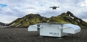
“We continually improve reliability by making small changes, for instance to how we attach motors, based on that accumulated experience,” Guay continues. “We have the certifications, procedures and staff to operate smoothly throughout the year.” UK operator Menapia aims to emulate Meteomatics by profiling continuously every hour for a month in Iceland.
Approval challenges
A UAS-DC flight period scheduled to close in September 2024 was extended to March 2025 at the request of some operators. Menapia paused its contribution within the original timeframe to allocate finite resources to customer contracts, which included flying drones from a ship in the Atlantic to study convection around the intertropical convergence zone.
Initially, Menapia planned a UAS-DC campaign on home soil but realized the UK Civil Aviation Authority (CAA) was unlikely to issue approvals in time. “The CAA lacks resources to process the current volume of applications,” says Pickering. “It’s still discovering what it considers acceptable risk-tolerance in UAS applications while switching to an EU-style specific operations risk assessment (SORA), which may allow some automated approvals in the future.
“Quite last-minute, we pivoted to Iceland,” he continues. “Iceland’s airspace is less congested and its population close to zero in places, making air risk and ground risk much lower.”
Menapia is now spooling up for an Icelandic campaign with its highly automated MetSprite platform (see Menapia’s contribution to the WMO UAS-DC project, p18). “Spooling up means gradually increasing the flight hours aircraft are exposed to,” says Pickering. “Our test regimes have to capture the unknown unknowns, issues we wouldn’t anticipate.”
He expects the campaign to raise the bar for routine capability and provide proof of reliability to regulators of more congested airspace. “Assessing forecasting benefits requires routine observations,” he adds. “Rather than submit occasional sputters of data, we decided to wait until we could do a high-quality submission.”
How UAS data can benefit NWP models
The overall WMO project is now looking to its second phase, assessing the benefit of the data collected to NWP models. “We’re now in discussion with NWP centers,” says WMO scientific officer and UAS-DC project manager, Nicolás Rivaben. “The best metric to assess UAS data may differ between standard NWP models and spectral models with four-dimensional variational data assimilation (4D-Var). We need to agree on which metric allows us to best assess impacts in all the models.”
Evaluating centers include the European Centre for Medium-Range Weather Forecasts (ECMWF), German Weather Service (DWD), Japanese Meteorological Agency (JMA), National Oceanic and Atmospheric Administration (NOAA) laboratories and the UK Met Office. German centers that ingested some UAS-DC observations in real time expect improvements in forecast accuracy, based on initial comparisons. “We anticipate a number of observing system experiments (OSEs),” says Pinto. “Modelers will compare the skill of simulations assimilating conventional observations with that obtained when also assimilating UAS observations.”
A final report may embolden the WMO to propose approval of UAS observations as standard NWP data to its members in 2026. “It’s a slow process,” says O’Sullivan. “OSEs are useful in testing the impact with archive model runs. Getting observations into operational assimilation systems at national centers requires a longer evaluation period.”
Menapia and Meteomatics base confident business cases on a further methodology: observing system simulation experiments (OSSEs). “OSSEs start with one high-resolution model run, which represents the truth,” Pickering explains. “From that, observations from both existing and hypothesized technologies can be simulated. Normal-resolution models can then be run with and without hypothesized drone observations and their accuracy compared.”
Pickering points to a recent US NOAA OSSE study showing up to 20% reductions in model errors at the first time step even with a widely spaced UAS network. Such networks may gap-fill regional coverage, eventually contributing to the WIGOS global system. “Because most UAS are confined to 2km altitude, the most likely impacts are local, including short-term predictions of high-impact weather,” adds Pinto.
“In the UK, UAS data may help to improve fog prediction,” O’Sullivan suggests. In-situ UAS observations from Africa or Antarctica could resolve uncertainties in global models. “Stratospheric UAS combined with dropsondes could cover those data-sparse areas. Perhaps met services will collectively fund systems that improve everyone’s forecasts,” O’Sullivan adds.
Climatic and regulatory challenges
Fewer than 10% of UAS-DC flights were terminated, mostly due to winds or icing – hazards that developers must mitigate against to enable routine observations. Menapia’s MetSprite has shown theoretical 97% ‘flyability’ to 2km altitude with a high thrust-to-weight ratio optimizing wind tolerance. Meteomatics has developed an industry-first self-deicing propeller.
“In northern climates, we frequently operate in sub-zero conditions,” says Guay. “When a drone enters icing conditions, 1cm of ice can accumulate on propellers within two minutes, taking it out of the sky.” But the propeller system of Meteomatics’ Meteodrone MM-670 senses such conditions and activates a deicing system, enabling operation down to -45°C. “That’s a major advance,” Guay says.
Believing in good relationships, both Meteomatics and Menapia dedicate teams to liaising with regulators, the most influential being the European Union Air Safety Agency (EASA) and FAA in the US. As Menapia’s UK travails illustrate, operational aspirations count for little without timely approvals. “The regulatory aspect needs untangling,” says Pinto. “The FAA has automated Part 107 approvals for flights up to 400ft [122m]. The next step would be streamlining an approval process for profiling flights to 5,000ft [1,524m], which can take months today.”
Regulation varies between countries and locations. Drones may be confined to operating in Class E airspace away from cities and airports – whereas the weather happens everywhere.
The UAS-DC was intended to stimulate conversations with civil aviation authorities and the International Civil Aviation Organization (ICAO), which represents them globally. “We need to develop a framework between the WMO and ICAO, so our respective members can connect at national level,” says Rivaben. “Civil aviation agencies must define if drones require transponders or traffic collision avoidance systems.” Rivaben arrived at WMO headquarters in Geneva from Argentina’s Servicio Meteorológico Nacional in February 2024. He credits his predecessors, Finland’s Pekka Rossi and Australia’s Dean Lockett, with the project’s essential design. “I just want to contribute my grain of sand,” he says. “We invest energy to spark development elsewhere.”
Pinto considers the standardized UAS data format a crucial project achievement that is already enabling downstream adoption, and hails the campaign a success in demonstrating real-time – and in some cases routine – capabilities, materially advancing the case for UAS in operational meteorology. “We knew it was possible but it hadn’t been demonstrated,” he asserts. “Now, it boils down to whether we see sufficient benefits to make deploying networks of UAS and assimilating the data economically viable for weather services. It may take two years for those studies to be published.”
On the web
The National Institute of Standards and Technology recently awarded the Oklahoma Aerospace Institute for Research and Education (OAIRE) US$5.5m to research how weather affects urban air mobility aircraft. The funds will contribute to research focused on the observation and investigation of the impact of low-atmosphere weather systems on uncrewed aerial systems (UAS) and advanced air mobility aircraft.
Meteomatics’ groundbreaking role in providing real-time UAS observations
Swiss weather company Meteomatics contributed the most UAS-DC profiles of any operator of UAS flown specifically to measure the atmosphere. Founded in 2012 to provide weather information to government and industry, it began experimenting with drones to increase the supply of measurements to its in-house models. “We started with a couple of sensors on a drone that reached maybe 50m then fell back down,” explains the company’s Brad Guay. “But we kept gaining experience and iteratively improving the platforms. Now, we’re starting to move out of research and to operationalize the technology.”
The Meteodrone MM-670 represents the current state of the art. Its six rotors are driven by individual, battery-powered brushless motors to support typical 22-minute flight profiles. Its basic sensors measure temperature, pressure, relative humidity, dew point and wind speed and direction, but it can be customized to carry other sensors.
“Getting sensors onto a drone and collecting reasonable measurements is relatively easy,” says Guay. “Doing that day in, day out in a range of conditions with full regulatory compliance and a high level of repeatability and autonomy is the hard part.”
The MM-670 features parachute rescue and optional propeller heating systems. It can operate at up to 6km altitude and in up to 90km/h winds. Furthermore, the Meteobase drone-in-a-box system enables someone at a PC in a faraway location to operate Meteodrones in multiple locations.
Meteomatics uploaded UAS-DC data from several operational sites and enabled a customer in North Dakota to contribute its own profiles. It recently secured a contract to deploy a 30-drone network across Norway to routinely supply data to the Norwegian Research Centre (NORCE), exciting enthusiasm from competitors.
“It’s the first major operational deployment of this technology,” says Menapia’s Ben Pickering. “NORCE is a military organization, and we don’t yet have national met offices using drone networks. But Meteomatics’ announcement is a big win for the industry.
Menapia’s contribution to the WMO UAS-DC project
Menapia’s Ben Pickering» Menapia’s flagship MetSprite WxUAS platform is a flying sensor suite deployable in individual nodes or coordinated networks. According to the company, unique aerodynamic design supports operation up to 6km altitude while algorithms optimize data collection.
“The MetSprite platform is a wind-tolerant, weather-resistant drone specifically developed for atmospheric profiling,” says Menapia’s Ben Pickering. “We custom-designed its temperature, humidity and pressure sensors in-house. Our calibration chambers enable traceable calibration two steps away from global references. That makes us competitive with ground stations used by national meteorological offices.”
Early WMO UAS-DC involvement saw Pickering co-author a white paper outlining the intended campaign. Menapia paused initial UK profiling plans to prioritize work with customers including TU Delft. Now, due to unforthcoming UK flight approvals, it is finally preparing for a continuous profiling campaign in Iceland. “Every hour, in a remote part of Iceland, a drone will fly out of a box while someone in our Leeds office in the UK monitors the flight on a screen,” Pickering says. This supervisor can perform three actions: conduct preflight checks, instruct the drone to return to base or abort the mission and trigger its in-built parachute.
“Based on our published pricing and recent OSSE results, we estimate at least a seven-times cost-benefit ratio,” he adds. “We’re cheaper than existing observing systems and more capable at scale. Besides meteorological sensors, we can carry aerosol, dust or gas sensors, meaning costs could be shared between applications.”
This article originally appeared in the January 2025 issue of Meteorological Technology International. To view the magazine in full, click here.