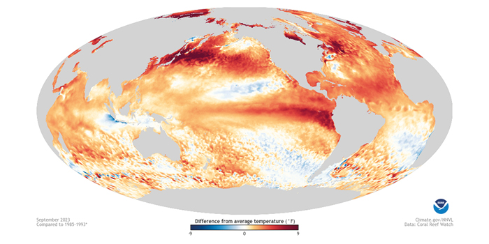
Ocean temperatures and their connections to weather trends have been making news. In response, five University of Washington (UW) experts offer their perspectives on the current El Niño – a climate pattern in the tropical Pacific Ocean that affects weather worldwide. UW researchers comment on the current El Niño and its effect on weather in the Pacific Northwest, as well as on regional and global ocean temperature trends.
Aaron Levine, a UW research scientist at the Cooperative Institute for Climate, Ocean and Ecosystem Studies, commented, “This El Niño has evolved in a really interesting way. Since spring, the dynamical models have very confidently predicted an El Niño event. But while the key region of the tropical Pacific has warmed quickly, the typical atmospheric response has lagged. The atmosphere in the tropical Pacific is only now becoming more typical of an El Niño event, although it is still not fully matching the ocean surface. That’s unusual, because the tropical ocean and atmosphere tend to evolve together.
“It will be interesting to see how this El Niño continues to evolve over the next few months, which will help determine the extent of impacts on our upcoming winter weather. Remote impacts in places like Seattle tend to be stronger for stronger El Niño events. While sea surface temperature has typically been the main measure, the impacts might very well depend more on the atmospheric response. So the evolution of the system over the next few months will be key to the eventual local impacts in places like Seattle.”
Dennis Hartmann, professor of atmospheric sciences at the UW, added, “The impact of El Niño on the Pacific Northwest varies a lot from one event to the other, depending on the spatial structure and size of the sea surface temperature changes in the tropics, and on the state of the atmosphere between the tropics and the Pacific Northwest. For that reason, the predictions of Pacific Northwest impacts based upon El Niño events that happened in the past are quite uncertain.
“In addition, the climate has warmed significantly in both the tropics and outside the tropics since some of the prior big El Niño events, in the 1970s and 1980s. That may add an additional complication to making an accurate forecast of how this winter will be different because of the current El Niño event.”
Nick Bond, a research scientist at CICOES and Washington’s state climatologist, said on El Niño and its effects on Washington’s weather, “El Niño conditions are present now in the tropical Pacific Ocean, and they are very likely to persist through the coming winter. The effects on Washington’s weather are expected to feature relatively warm, and perhaps drier, weather than usual after Jan 1, and ultimately a lower-than-normal snowpack in our mountains at the end of winter. El Niño’s impacts on the weather in Washington state tend to be more consistent in the middle to latter part of the winter. But this is not written in stone – there has been variability among past El Niños in terms of effects on Washington’s winter weather.”
Jan Newton, senior principal oceanographer at the UW Applied Physics Laboratory and director of the UW-based Northwest Association of Networked Ocean Observing Systems, on what oceanographers are seeing in regional waters, emphasized, “Conditions off Washington’s outer coast have varied and are mainly influenced by changes in coastal upwelling and downwelling in the Pacific Ocean. Temperatures off the outer coast are now 4°F (about 2°C) above normal, though variable.
“In Puget Sound, we’re starting to see surface water temperatures shift from cooler than normal, or normal, to consistently warmer than normal, but only by less than 1°F (0.5°C). Given the large-scale warmth in the satellite-measured sea surface temperatures offshore, I do expect that we will continue to see warmer-than-normal sea temperatures in Puget Sound. However, it’s hard to predict if these differences from the average will stay small or will increase. What happens next will depend on ocean conditions and local weather.”
LuAnne Thompson, UW professor of oceanography, on the record-breaking temperatures in the Atlantic Ocean, especially off Florida and Newfoundland, stated, “The recent acceleration of ocean warming in the Atlantic is unprecedented in the historical record, and has created an Atlantic-wide marine heatwave. The ability of the ocean to absorb and store vast amounts of heat makes these types of events last longer. I study marine heatwaves with a focus on their evolution in time and space. However, with more long-lasting, basin-wide events, such as the one we are seeing now in the Atlantic Ocean, we will need to reevaluate our approach.
“At a particular location, a marine heatwave occurs when the sea surface temperature is above a threshold, defined by what is typical for that time of year, and lasts for at least five days. However, with the global warming projected over the coming decades, these dangerous hot water events will no longer be localized and of finite duration – they will no longer fit the traditional definition of marine heatwaves. Instead, these marine heatwave events will become more persistent and widespread, and eventually will cover entire ocean basins.”


