


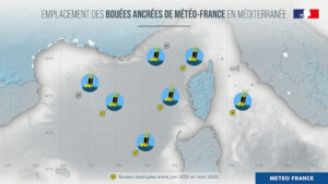
On March 5, 2025, Météo-France launched the fifth in a series of meteorological buoys on the western front of the Mediterranean, northwest of Corsica. This deployment forms part of the organization’s plans to strengthen its sea observation system, which began in June 2023 with the deployment of the first of the five anchored meteorological buoys, and is intended to improve the local ability to anticipate extreme weather before it arrives on land.
The meteorological buoys were financed mainly by the Ministry of Ecological Transition, Biodiversity, Forestry, Sea and Fisheries, via the Directorate-General for Risk Prevention (DGPR). The services of the Directorate-General for Maritime Affairs, Fisheries and Aquaculture (DGAMPA) has entrusted the support of the launch and withdrawal operations to the Interregional Directorate of the Mediterranean Sea (DIRM MED) and the Lighthouse and Beacon Equipment Agency. Météo-France will ensure the assembly, preparation, operation and maintenance of these buoys.
What parameters do the meteorological buoys measure?
The anchored buoy is a meteorological measuring instrument with a floating structure, installed in the open sea. It is equipped with two independent weather stations, powered by solar panels. Its frame is formed by a yellow float, a steel keel and a mast on which sensors are fixed. The buoy is up to 7m high (half of which is submerged) and weighs more than three tons, and its anchor line can reach 6km deep in the sea.
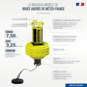
The anchored buoy makes it possible to measure and transmit in real time meteorological parameters such as wind, air temperature, atmospheric pressure and air humidity, but also oceanographic parameters (such as the height or frequency of waves and temperature and salinity of the sea). These measurements are recorded by sensors. The data is transmitted live and fed into various numerical models which are used by Météo-France forecasters.
Can you tell me a bit more about the technological design of the deployed buoys?
These five buoys are innovative models. They feature a closed structure at the top of the buoy to protect the electronic core of the station and facilitate its maintenance, either on a boat or directly at sea on the buoy. Working conditions are therefore secure. They also present a logistical gain as the anchored buoy is now transportable inside a standard container. Additionally, it features eco-responsible materials as a core part of its design, including empty float, food plastic, ultra-resistant and recyclable elements.
Why has the sea observation system been strengthened?
To make its forecasts, Météo-France relies on observations. The latter are rare off the coast. Weather satellites partially make up for this, radars do too, but they limit their maritime observation to direct proximity to the coasts (this is the case for precipitation, for example) and not to the surface of the sea. Similarly, some boats carry out some meteorological measurements, but unfortunately, there aren’t enough of them and they need to avoid areas where activity is dangerous.
The deployment of five buoys in the Mediterranean therefore aims to improve coverage in surface observations at sea in this region, and to improve weather monitoring and immediate forecasting (such as the arrival of a thunderstorm). During dangerous meteorological events, such as a thunderstorm or a Mediterranean episode, the data transmitted by the buoys will be essential when the weather scenarios diverge on the intensity and location of the phenomenon. The data transmitted in real time will make it possible to confirm or rule out a scenario and to re-track the episode on the basis of proven observations.
How have the buoys affected operations so far?
The first buoy deployed in June 2023, for example, provided important information during violent thunderstorms that circulated on August 27 and 28, 2023, in the Mediterranean. The scenario chosen by the forecasters predicted that the storm would pass south of Corsica, with violent gusts expected on the island. The data transmitted by the buoy during the advance of the storm confirmed the trajectory and its intensity. An orange thunderstorm warning had been issued for Corsica.
The data from the buoys also made it possible to better understand the strong episodes that affected Corsica in the autumn of 2024 and were a valuable help for estimating the risk in the Provence-Alpes-Côte d’Azur area. This was the case, for example, between October 15 and 18, 2024, during a stormy deterioration that gave very large accumulations of rain over a large part of the territory, leading to sometimes devastating floods, especially in the southeast quarter where six departments had been placed on red alert for rain-flood and/or floods on Thursday, October 17.
Similarly, the reinforcement of the buoys proved useful during the Mediterranean episode from October 24 to 27, 2024. This episode was distinguished by its duration and the gradual accumulation of precipitation over several days. The coastal departments were the most affected, especially the Var and the Alpes-Maritimes.
In related news, Météo-France recently launched a call for tenders to renew its two supercomputers, Belenos and Taranis. The objective is to improve the reliability of forecasts, better anticipate high-stakes phenomena, more precisely simulate the future climate and support actions to adapt to climate change. Click here to read the full story.