A first-of-its-kind automated highway dust detection system has been developed by the Arizona Department of Transportation to keep citizens safe on the interstate during the North American monsoon season – the peak time for severe storms that create hazardous driving conditions
Between Phoenix and Tucson in Arizona, Interstate 10 (I-10) crosses 160km of wide-open desert. On a 16km stretch between Eloy and Picacho Peak, Arizona Department of Transportation (ADOT) has created an automated highway dust detection system that dynamically adapts the enforceable speed limit in response to roadside visibility data.
It includes a 6m Doppler radar tower that will enhance National Weather Service (NWS) coverage of the area. The US$6.5m system went live on June 15, 2020 – the start of monsoon season, when titanic dust storms roll across the desert.
“Dust storms are usually affiliated with the convective thunderstorms of the North American monsoon,” explains NWS Phoenix lead meteorologist Jaret Rogers. “As rain falls, the cloud begins to collapse and produces a huge outflow of wind.”
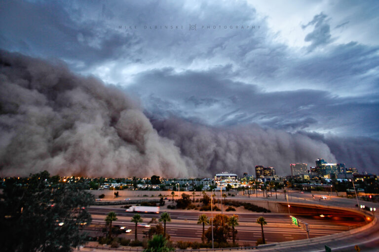
Horizontal 80km/h gusts billow outward, disturbing loose soil desiccated by months of aridity. “Outflow boundaries can travel 100 miles [160km], kicking up dust,” Rogers continues. “Eventually, that becomes a wall of dust.” Sometimes, that wall can be 96km wide and tower 305m above the desert. Suddenly, driving south from Phoenix seems like driving on Mars, enveloped by planet-wide dust storms.
“Visibility is reduced and traffic slows to a crawl,” says ADOT systems maintenance manager, David Locher. “I’ve had trouble seeing the end of the hood on my truck.” ADOT advises motorists to pull over, kill their lights and disengage the brake pedal. “That way, people won’t follow you,” Locher explains. “We’ve had commercial vehicles drive into dust without stopping and rear-end passenger vehicles.”
A study of incidents on I-10 provided the impetus for dust detection. “Of 80-odd accidents on a 100-mile stretch, 43 occurred within one half-mile [0.8km],” Locher comments. Backed by a supportive governor and federal FASTLANE funds, ADOT set about building its system.

Informed decisions
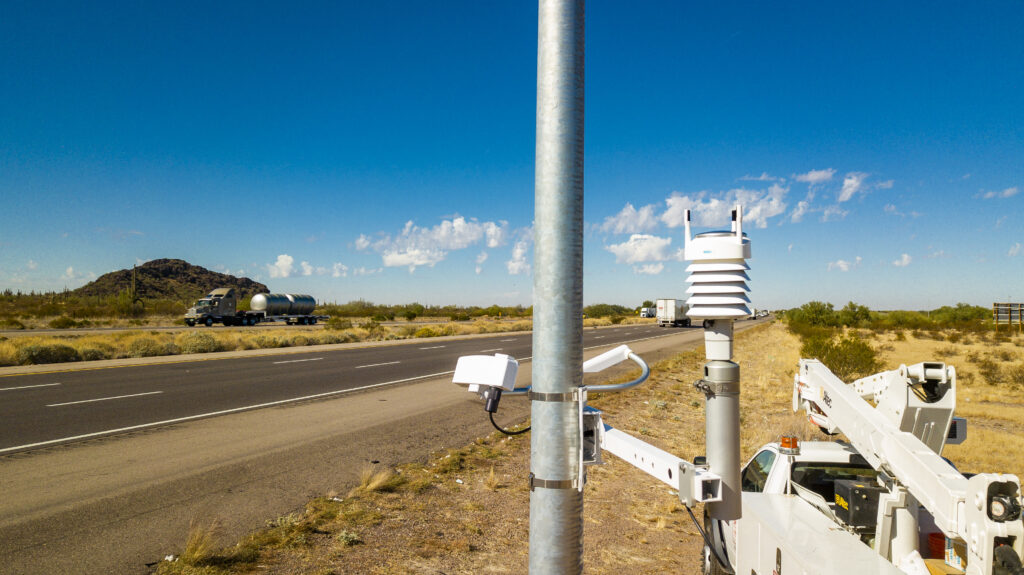
Thirteen roadside Vaisala PWD10 visibility sensors are positioned at driver’s-eye level. “Airports use PWD sensors for applications including fog warning systems,” says Vaisala’s ground transportation application manager, Rose Parisi. “They determine visibility and meteorological optical range by measuring scattered light from particles between two sensor heads.” As visibility deteriorates, an algorithm decreases the enforceable speed limit displayed on variable LED signs.
“The dust detection system correlates airborne particles to a visibility sight distance,” Locher comments. “Once visibility drops below 1,800ft [548m], it reduces the speed limit from 75mph [120km/h] down to 35mph [56km/h] in 10mph [16km/h] increments.”
Staff at ADOT’s Phoenix Traffic Operations Center can verify the dust alert via CCTV; variable message boards forewarn motorists leaving Phoenix and Tucson. “We’re fine-tuning our ability to populate messages automatically,” says Locher. “We can tell people there’s a likelihood of dust 50 miles [80km] from the corridor, enabling them to make informed decisions.
“What’s new isn’t the hardware, but the integration itself,” Locher continues. “It’s a fully automated system that doesn’t require human activation or approval. It sees reduced visibility, automatically reduces speed limits, then automatically returns to normal by itself.”
ADOT conducted a 30-day pilot before operations commenced. “We ran everything on a test server with real data coming in from the road,” Locher says. Finally, the system went live. But days passed, then weeks… and no dust came to test it. “We had some activations when maybe a farmer was plowing, but those events are generally short-lived.”
Dust sources adjacent to I-10 are partly the result of past agricultural practices. “Drive past Picacho and Eloy today and there’s nothing out there, but several uses have cycled through,” says University of Arizona distinguished professor Eric Betterton. “In the West, farmers can access vast range lands for little or no charge. Once there were pistachio orchards, which mitigated the wind speed. There was cotton farming, so the land was irrigated and planted.” If once-cultivated land is left neglected, it becomes a potent dust source, as does finely ground rock from mine tailings if they are not kept damp, as per best practice.
“Ultimately, if you control the source of dust, all the other problems go away,” Betterton adds. He advocates soil treatment in parallel with detection and forecasting efforts. Arizona Department of Environmental Quality (ADEQ) used this strategy further east near San Simon, when ill-advised plowing led to dust-related road fatalities.
“ADEQ made the farmer spray the land with water then apply a soil amendment,” says Betterton. “A thin adhesive bonds soil particles together, providing a temporary protective skin.” Planting vegetation and limiting access to land would suppress dust further. “The state could intercede to treat these well-known dust sources,” Betterton concludes.
Capturing dust storms
Close collaboration with NWS led ADOT to install a 6m Doppler radar tower on I-10, supplementing close-vicinity detection with the capability to see dust storms 64km away. It fills in the blanks in formerly imperfect NWS coverage from weather radars in Phoenix and Tucson.
“For detecting thunderstorms, there’s no real gap,” explains Rogers. “But dust storms happen near the ground, whereas radars look upward at an angle. Fortunately, ADOT had funding for a radar. It’s another tool that enables us to capture and characterize dust storms moving through that area.”
Generally, Arizonans are aware of a major dust storm on the move. “There’s a dramatic media display,” says Rogers. “They send up helicopters to film it coming.” Plus, NWS Phoenix triggers the multichannel US Emergency Alert System, which sends push notifications to cell phones within a geofenced area.
“We have high confidence when we issue a warning, and people take them seriously,” says Rogers. Yet the typical lead time is an hour at most, and dust remains hard to predict on longer timescales with any certainty. “There’s no direct way to forecast specific dust storms,” Rogers explains. “Obviously, you need potential for thunderstorms – and weather-model resolution is continually improving. But you also need to know the state of the soils, which is beyond our expertise as meteorologists.”
Nevertheless, NWS Phoenix has correctly identified days of enhanced risk for several consecutive years. “Really it’s just knowing, historically and climatologically, that storms in certain spots have potential to kick up dust,” says Rogers. “Observationally, our ability to characterize soils could still improve.”
Dust only becomes airborne when wind velocity exceeds the threshold necessary for saltation to occur. “Electrostatic forces make small soil particles adhere to larger ones, but a sufficiently strong wind lifts medium-size particles from the surface,” Betterton explains. “They bombard and dislodge the finer particles, which become suspended in the wind.”
Dust doesn’t increase gradually with wind speed, but appears suddenly once a threshold is passed. “We’ve been in the desert with a portable wind tunnel, varying wind speed to determine that minimum velocity,” Betterton adds.
Improving accuracy
If localized sources were characterized and saltation wind-velocity thresholds integrated in weather models, dust might be forecast with greater certainty. But that integration is no trivial task. “The soil surface really matters,” says Betterton. “If it rained yesterday and shut down dust production, you need to know. But that’s asking a model, which looks forward, to look back in time and change itself as a result.”
ADOT’s system also features a Vaisala WXT536 Weather Transmitter. “The WXT536 is a multiparameter sensor providing wind, temperature, relative humidity, precipitation and barometric pressure observations,” says Parisi. “Humidity measurements help factor out false readings from fog or rain, because high humidity makes dust unlikely.” Dust-storm data can be hard to come by and ADOT expects the additional measurements to feed future University of Arizona research. “Vaisala has participated in applications that dynamically adjust speed limits based on road condition, road friction, wind and precipitation data,” Parisi adds.
In a state of contrasting extremes, ADOT periodically contends with wildfires. “One fire took out 10 miles [16km] of wooden freeway guardrail,” Locher recalls. “Rain on burnt areas then causes flash floods, sometimes with sad results.”
Flagstaff, three hours north of Phoenix, enjoys an alpine climate of mild summers and snowy winters. Here, ADOT will adapt its algorithm and use different sensors for automated safety on icy mountain roads. For now, the ADOT system has yet to encounter a major dust storm after 2020 proved a ‘nonsoon’ year. “The monsoon season was a total dud,” says Locher. “That’s a blessing, because they wreak havoc, but we wanted one to test the system!”
So far, ADOT has had only praise, both from locals and those passing through what is a major coast-to-coast corridor. Minor dust events have twice reduced the speed limit to 56km/h, and embedded loops revealed average driver speeds of 72km/h. “That’s pretty good,” says Locher. “People were slowing – either because they respected the system, or because they couldn’t see.”


