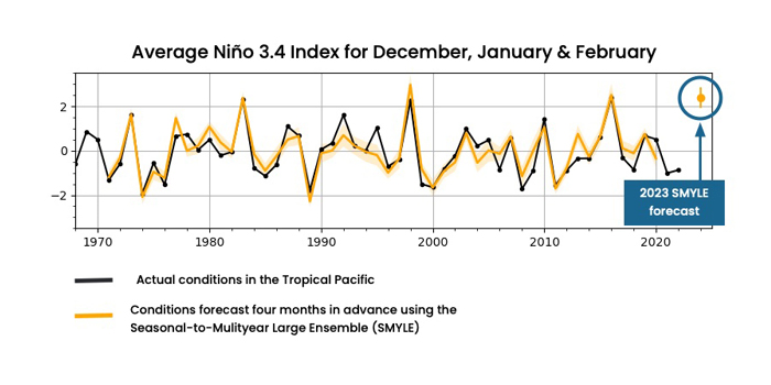
According to an experimental prediction system developed by the National Science Foundation’s National Center for Atmospheric Research (NCAR), current El Niño conditions are likely to develop into one of the strongest events on record.
“Our forecast system has shown that it can do a remarkably good job of accurately hindcasting past El Niño events when we’ve tested it using historical data, which gives us high confidence in this forecast,” said NCAR scientist Stephen Yeager, who helped lead the modeling effort.
Scientists commonly define El Niño events using a metric called the Niño 3.4 Index, which is a measure of how much warmer (or cooler) the sea surface temperatures are in a defined rectangle of the Tropical Pacific Ocean, compared with the long-term average. El Niño conditions occur when the average Niño 3.4 Index is above +0.5°C. An official El Niño event requires the running three-month average index to be +0.5°C or higher for five consecutive months.
The Niño 3.4 Index for August was +1.3°C. NCAR’s new forecasting system predicts the index will rise to an average of +2.4°C over the months of December, January and February. The 1997-98 El Niño also peaked at a three-month average of +2.4°C. The slightly stronger 2015-16 event peaked at +2.6°C.
The experimental NCAR El Niño forecast was born out of an effort by NCAR scientists and their colleagues in the research community to explore more thoroughly what phenomena in the Earth system might be predictable a season to two years in advance. Extending forecasts beyond the two-week weather window is the focus of much research in the Earth system science community. However, much of the work has either been directed at the subseasonal-to-seasonal timeframe (from a couple of weeks to a year out) or in the decadal timescale (several years to a decade out), leaving a gap in the middle.
To fill the hole, NCAR’s researchers developed a new protocol for running the NCAR-based Community Earth System Model, version 2 (CESM2). The project was devised and executed by the CESM Earth System Prediction Working Group, a collection of experts from NCAR and the community interested in advancing our fundamental understanding of Earth system predictability on timescales running from subseasonal to decadal.
The group performed an extensive series of hindcasts. For each year from 1970 through 2019, the scientists ran quarterly hindcasts. The simulations took into account not just the historical conditions in the atmosphere but also the state of the oceans, sea ice and land. This is different from weather models, which typically rely only on atmospheric conditions to begin their forecasts.
Once the model was initialized with the historical data, the scientists ran forward two years. For each quarter they ran 20 simulations, for a total of 6,400 simulated years.
The resulting data set, called the Seasonal-to-Multiyear Large Ensemble (SMYLE), is a freely available trove of information that researchers can use to search for phenomena that may be predictable. By comparing simulation results with what actually occurred, scientists can identify the events that we have the best chance of accurately forecasting in the future. The types of phenomena that scientists think may have at least some ability to be predicted in the seasonal-to-multiyear timeframe include sea ice thickness, snow cover, ocean acidification and upper ocean temperatures in some regions, among others.
An initial analysis of SMYLE also revealed that the system did a remarkably good job of forecasting the occurrence and strength of El Niño and La Niña events. With an El Niño taking shape this autumn, the Earth System Prediction Working Group decided to run the system in real time in August 2023, producing a 20-member ensemble forecast for the upcoming winter.
The predicted El Niño of +2.4°C average over December, January and February is higher than predicted for the same time period by the dynamical models used for the standard El Niño forecasts, but it is still within the range.
The average forecast produced by the standard models (also run in August) predicted an index of +1.86°C. But some individual models predicted a stronger El Niño, including the European Centre for Medium-Range Weather Forecasts (ECMWF) model, which predicted +2.35°C, and the Meteo France Seasonal Forecast, which predicted +2.41°C.
“Our system is predicting a warmer event than many other systems,” Yeager said. “But it isn’t out of the realm of possibilities. Only time will tell if we’re accurate, but we believe our system has something to offer and we’re excited to be able to contribute this knowledge to the conversation going on right now about the impacts El Niño may have in the coming months.”


