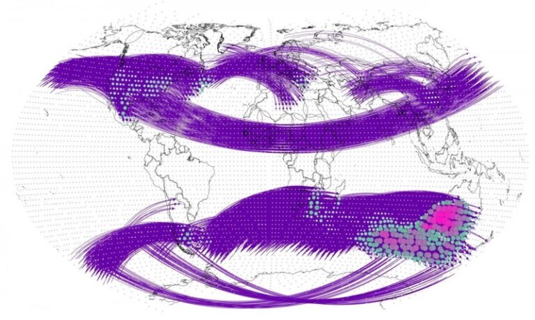
A team of researchers from across the world has developed a climate network analysis method to explore the intensity, distribution and evolution of teleconnections to help pinpoint regions at higher risk of extreme weather.
The team of researchers is affiliated with Beijing Normal University and Beijing University of Posts and Telecommunications in China and the Potsdam Institute for Climate Impact Research in Germany. They published their findings in a paper in the journal Chaos, from American Institute of Physics (AIP) Publishing.
According to the paper, tracking climate behavior could connect the dots between major weather events and help with forecasting on a global scale. The researchers asserted that climate change and the rapid increase in the frequency of extreme weather events around the globe – such as wildfires and floods – reinforces the reality that these events are not only not random but, rather, interconnected. The report went on to say interlinked climate behavior, or teleconnections, isn’t a well-understood field but will be necessary to fully comprehend how our climate system works.
Climate networks are akin to maps where data points are marked as locations, and the connections between them reveal similarities. The researchers’ climate network analysis method combines the directions and distribution patterns of teleconnections to evaluate their intensity and to identify sensitive regions using global daily surface air temperature data. Their method relies on advanced data processing and mathematical algorithms to find meaningful insights.
“Teleconnections describe how climate events in one part of the world can affect weather thousands of kilometers away,” said co-author Jingfang Fan of Beijing Normal University and the Potsdam Institute for Climate Impact Research. “Think of it as a domino effect on a global scale. And then there’s global warming – the Earth is becoming hotter. Within just five years, we may see temperatures rising to levels that global scientists have been warning us about. It’s like the planet is running a fever that’s steadily getting worse. Our work uncovered patterns in climate events driven mainly by atmospheric Rossby waves, which are large inertial planetary waves that naturally occur in rotating fluids and cause movement within the atmosphere.”
The team identified areas significantly affected by these interconnected events, within regions like southeastern Australia and South Africa, which are particularly sensitive. One discovery they made is that these interconnections are becoming stronger over time, from 1948 to 2021, possibly due to a mix of climate change, human activities and other factors. The extent and intensity of the impact of teleconnections has increased more prominently in the Southern Hemisphere during the past 37 years, the researchers state.
This work is intended to provide a new way to measure and explore climate teleconnections. The researchers plan to use this knowledge to pinpoint which regions may be at a higher risk in the future and to devise strategies to address these challenges.
“The next step is like weather forecasting – but on steroids,” said Fan. “Using what we’ve learned, we plan to predict how climate events will unfold and connect. We’re diving deep to explore why these events happen and how various climate ‘tipping points’ within our climate system might be linked.”
For more key extreme weather updates from the meteorological technology industry, click here.


