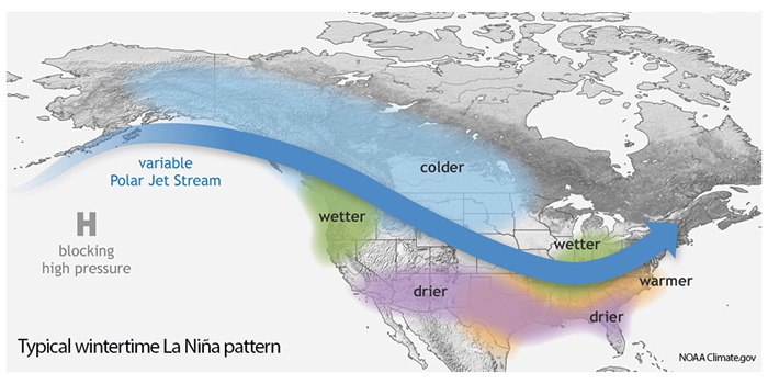
A La Nina climate pattern has developed and is likely to persist through the winter, according to an advisory issued by NOAA’s Climate Prediction Center.
The natural ocean-atmospheric phenomenon is marked by cooler-than-average sea surface temperatures across the central and eastern Pacific Ocean near the equator, the opposite of El Nino which features warmer-than-average sea surface temperatures in that region.
“La Nina can contribute to an increase in Atlantic hurricane activity by weakening the wind shear over the Caribbean Sea and tropical Atlantic Basin, which enables storms to develop and intensify,” explained Mike Halpert, deputy director of NOAA’s Climate Prediction Center. “The potential for La Nina development was factored into our updated Atlantic hurricane season outlook issued in August.”
For the months ahead, NOAA say there is a 75% chance that La Nina will be in place from December 2020 through February 2021. During the winter, La Nina typically brings above-average precipitation and colder-than-average temperatures along the northern tier of the USA, along with below-average precipitation and above-average temperatures across the South. A region of concern this winter will be the Southwest, where a weak summer monsoon resulted in extreme drought.
The last La Nina appeared during the winter of 2017-2018, and El Nino followed in 2018-2019. When neither climate pattern is present, notes NOAA, as was seen during the winter of 2019-2020, the El Nino Southern Oscillation (ENSO) is neutral and does not influence global climate patterns.


