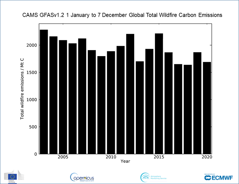
New research from the Copernicus Atmosphere Monitoring Service (CAMS), which has spent the year tracking the devastating wildfires that have occurred in several hotspots across the world, has revealed that despite some regions such as the western USA being particularly badly hit, there have been fewer wildfires across the globe, continuing a trend of declining emissions since 2003.
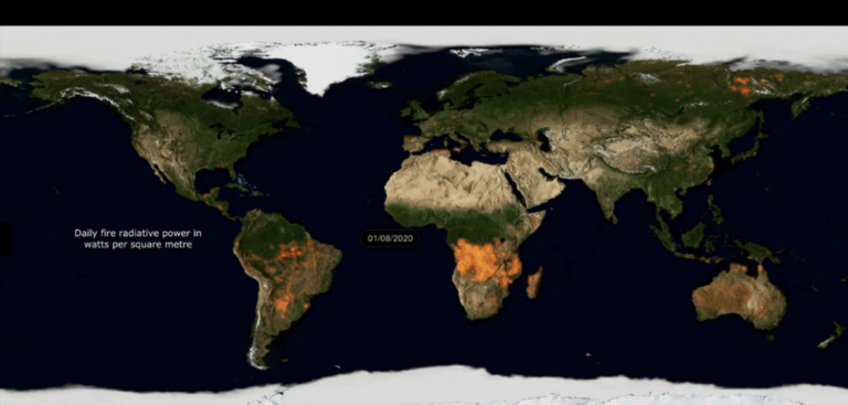
CAMS scientists monitor daily wildfire activity around the world using a measure of heat output called Fire Radiative Power (FRP). These observations come from satellite-based sensors which can detect the heat signal and are used to estimate the intensity of fires. The CAMS Global Fire Assimilation System (GFAS) uses these near-real-time observations of the location and intensity of active wildfires to estimate the emissions of pollutants. To illustrate fire activity in 2020, CAMS has created a designated animation. Furthermore, CAMS scientists can confirm that 2020 has seen one of the lowest years of fire activity in its GFAS data set, which began in 2003, but in the worst affected areas, the intensity has been far higher.
While fire activity in southern tropical Africa has been very low this year, there has been enhanced activity in areas such as Siberia, Colorado, California and the Pantanal region of southern Brazil. In 2020, approximately 1,690 megatonnes of carbon have been discharged into the atmosphere from January 1 to December 7, 2020. This compares to 1,870 megatonnes of carbon emitted in 2019 and continues the pattern of lower emissions.
Mark Parrington, senior scientist and wildfire expert at CAMS, explained, “While 2020 has certainly been a devastating year for wildfires in the most badly affected hotspots, emissions across the world have been lower due to better fire management and mitigation measures. Since we began monitoring wildfires via our GFAS system in 2003, we have seen a gradual decline in emission rates. However, this is no time to be complacent as wildfires in the worse affected areas were of record intensity as a result of warmer, drier conditions. This resulted in increased pollutants being carried thousands of miles, affecting air quality for millions of people.
“By continuing to monitor the scale, intensity and emissions of these wildfires on a daily basis across the globe, our aim is to raise awareness of their long-lasting and large-scale impact. This helps inform policymakers, organizations, businesses and the individual citizen to plan against the potential effects of air pollution, particularly important now that the Covid-19 pandemic has hit us.”
You can find more information, animations and graphs about this year’s wildfires here.


