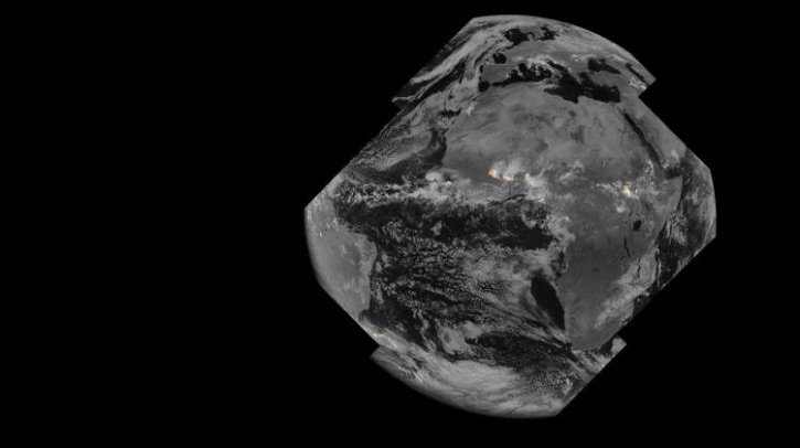
EUMETSAT has begun disseminating data from the lightning imager carried on the Meteosat Third Generation – Imager 1 (MTG-I1) satellite, which was launched at the end of 2022. The lightning imager was built by Leonardo.
MTG-I1’s lightning imager technology
The lightning imager on MTG-I1 has four cameras with fields of view covering Europe, Africa, the Middle East, parts of South America and most of the Atlantic Ocean. The cameras continuously observe lightning activity from space and can capture 1,000 images per second, detecting even a single lightning flash faster than the blink of an eye.
Storm data dissemination
“This is the first time weather forecasters from Europe and Africa will have access to this type of data, which we expect will help them monitor and predict the development, track and severity of storm activity,” EUMETSAT director-general Phil Evans said. “This is important information for the protection of communities and vital industries, such as aviation, during severe weather events. Severe storms are often preceded by abrupt changes in lightning activity. By observing these changes in activity, lightning imager data will give weather forecasters additional confidence in their forecasts of severe storms.”
EUMETSAT has begun disseminating the data to weather services in its member states and other users. Crucially, it is delivering the data to weather services in Africa and other regions where lightning detection capability with ground-based observations is limited.
The dissemination is currently pre-operational. This means that, although the quality of the data is the same as that of operational data, there could be some disruptions for testing or software upgrades, for example.
“During the European summer there is often storm activity,” Evans said. “This is an opportune time to provide lightning imager data to weather forecasters. The feedback we receive will help us validate the data later this year when we switch to an operational service. The switch to an operational service is expected to be seamless and without disruption to users of the data.”
EUMETSAT will schedule training on the use of the lightning imager data to ensure users gain maximum benefit.
Europe
This animation shows the development and movement of thunderstorms over Europe. Every frame shows the flashes over the past two hours, colored from white (those occurring in the most recent 20 minutes) to dark red (100-120 minutes ago). Larger and more persistent eastward-moving lightning clusters in the eastern and south-eastern parts of Europe represent mesoscale convective systems. More localized short-lived afternoon thunderstorms appear in Italy and over the Alps. On the last day shown in the animation, a high-latitude outbreak of thunderstorms moving eastward from Finland can be seen. Smaller stripes of flashes are visible within wider storm areas, demonstrating that the lightning imager is capable of tracking individual storm cells. This animation was made using three days’ worth of lightning flash (LFL) data from the MTG-I1 lightning imager, from 00:00 UTC 22 June 2024 UTC to 23:59 UTC 24 June 2024.
Full-disc
This animation shows the full field of view of the MTG-I1 lightning imager, covering about 84% of the visible disc. Most of the lightning activity occurs in the Intertropical Convergence Zone (ITCZ), located to the north of the equator during the Northern Hemisphere summer. Here, the formation and westward movement of large, long-lived thunderstorm clusters or mesoscale convective systems can be seen. This differs from the eastward movement of mid-latitude thunderstorms that can be seen in Europe and the southern part of the Atlantic Ocean. The video demonstrates that the lightning imager can detect high-latitude lightning in the northeastern part of Europe, as well as thunderstorms very close to the edge of its field of view in South America. This animation was made using 24 hours’ worth of accumulated flash area (AFA) data from the MTG-I1 lightning imager, from 00:00 UTC to 23:59 UTC 24 June 2024. The data is not for operational use.
The Intertropical Convergence Zone
The Intertropical Convergence Zone is characterized by continuous lightning activity. During the Northern Hemisphere summer, most of the activity is located to the north of the equator. The beginning of the animation shows mesoscale convective systems. These long-lived thunderstorm clusters can grow larger than 1,000km. The most intense convection and lightning activity occurs along the leading edge of such cloud systems. The lightning imager accumulated flash area highlights these areas and resolves individual storm cells with the highest lightning activity. Later in the afternoon, many new storms develop over the sun-heated surface. Some smaller localized storms quickly die out after the sunset while others merge into new mesoscale convective systems and stay active throughout the night. This animation was made using 24 hours’ worth of acumulated flash area (AFA) data from the MTG-I1 lightning imager, from 00:00 UTC to 23:59 UTC 24 June 2024. The data is not for operational use.
In related news, EUMETSAT recently awarded a launch service contract to SpaceX for the launch of the Meteosat Third Generation-Sounder 1 (MTG-S1) satellite on a Falcon 9 rocket in 2025. Click here to read the full story.


