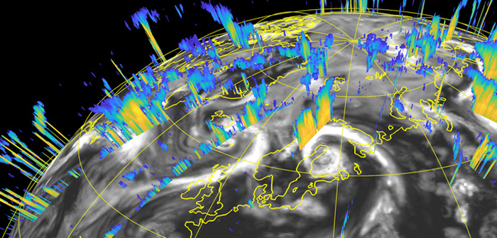
Scientists from the European Centre for Medium-Range Weather Forecasts (ECMWF) have demonstrated that cloud radar and lidar data in operational global numerical weather prediction improves forecasts.
The research by Marta Janiskova and Martin Fielding is being demonstrated at the joint NWP SAF/ECMWF/JCSDA workshop on assimilating satellite cloud and precipitation observations, taking place at the center from February 3 to 6.
Janiskova said: “There were doubts whether assimilating 3-D cloud profile data covering a very narrow band along the satellite’s path would even be possible. That is why we are extremely pleased to see that our tests show signs of improvement in forecasts even before extensive tuning has taken place.”
Data assimilation is the process of combining Earth system observations with model information to produce the best possible estimate of the current state of Earth. The estimate, called the analysis, is used as the starting point for forecasts.
One of the main difficulties in satellite data assimilation is that the instruments used do not directly measure the quantities predicted by forecasting systems.
Cloud radar and lidar equipment are an example of this, beaming radio waves and laser light down into the atmosphere and measuring the radar reflectivity and lidar backscatter. The radar signal penetrates clouds and its reflection can provide profile information.
The lidar signal quickly weakens inside clouds so the backscatter mainly provides information on cloud top height. To be able to compare such data with model data, the latter need to be transformed into simulated satellite data using an ‘observation operator’.
Developing and optimizing the observation operator for cloud radar and lidar was a major part of the preparatory work.
Fielding commented: “One of the greatest challenges was to accurately estimate observation operator errors as well as representativeness errors. For example, how representative is the satellite data given their small footprint?”
The work complements existing ECMWF work to better exploit observations of clouds and precipitation in the ‘all-sky’ system.
Janiskova commented: “Radar and lidar are active instruments that measure vertical profiles. There was little previous work to go by because most satellite instruments do not measure such profiles.”
Fielding and Janiskova say their work is not finished, as the test results were obtained using a previous version of ECMWF’s Integrated Forecasting System IFS Cycle 43r1.
The next step will be to transfer the code they developed to the current version, IFS Cycle 46r1.
*This is an edited version of a longer article published on the ECMWF website on February 3.


