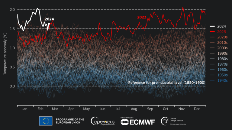
The Copernicus Climate Change Service (C3S), implemented by the European Centre for Medium-Range Weather Forecasts on behalf of the European Commission with funding from the EU, has found that global sea surface temperatures reached a record high in February 2024.
All the reported findings are based on computer-generated analyses and according to the ERA5 reanalysis data set, using billions of measurements from satellites, ships, aircraft and weather stations around the world.
Additionally, February 2024 was the warmest February on record globally, with an average ERA5 surface air temperature of 13.54°C, 0.81°C above the 1991-2020 average for February and 0.12°C above the temperature of the previous warmest February (2016).
According to the research, this is the ninth month in a row that was the warmest on record for the respective month of the year. The month was 1.77°C warmer than an estimate of the February average for 1850-1900, the designated pre-industrial reference period. The global average temperature for the past 12 months (March 2023-February 2024) is the highest on record, at 0.68°C above the 1991-2020 average and 1.56°C above the 1850-1900 pre-industrial average.
The daily global average temperature was reportedly exceptionally high during the first half of the month, reaching 2°C above the 1850-1900 levels on four consecutive days (February 8-11). European temperatures in February 2024 were 3.30°C above the 1991-2020 average for February, with much-above-average temperatures experienced in Central and Eastern Europe. Outside Europe, temperatures were above average over Northern Siberia, Central and Northwest North America, the majority of South America, across Africa, and in Western Australia.
El Niño continued to weaken in the equatorial Pacific, but marine air temperatures in general remained at an unusually high level. The average global sea surface temperature (SST) for February 2024 over 60°S-60°N was 21.06°C, the highest for any month in the data set, above the previous record of August 2023 (20.98°C). Sea surface temperature is defined over the global extrapolar ocean, from 60°S to 60°N. This is used as a standard diagnostic for climate monitoring. The average daily SST reached a new absolute high of 21.09°C at the end of the month.
Boreal winter 2023/2024 (Dec-Jan-Feb) was the warmest globally at 0.78°C above the 1991-2020 average. European winter temperature was the second warmest on record, after the winter of 2019/2020, at 1.44°C above the 1991-2020 average.
Carlo Buontempo, director of the C3S, said, “February joins the long streak of records of the last few months. As remarkable as this might appear, it is not really surprising as the continuous warming of the climate system inevitably leads to new temperature extremes. The climate responds to the actual concentrations of greenhouse gases in the atmosphere so, unless we manage to stabilize those, we will inevitably face new global temperature records and their consequences”.
In February 2024, it was wetter than average in Europe in a large band from the Iberian Peninsula to Western Russia, and over the UK and Ireland, Southern Scandinavia, and the Alps. Precipitation was also above average over much of Italy. Wind and heavy rainfall associated with several storms caused widespread damage and disruptions.
Drier-than-average conditions were observed across most of the Mediterranean countries, parts of the Balkans, much of Turkey, regions of Iceland and Northern Scandinavia, as well as large parts of Western Russia. Beyond Europe, in February 2024 it was wetter than average over the West and the Northeast of North America, in a large region from Eurasia to Central Asia, in parts of China and Japan, in South-eastern Brazil, parts of Southern Africa and in Northern Australia. These conditions were often associated with the transit of cyclones.
Drier-than-average conditions persisted in parts of North America, the Horn of Africa, the Arabian Peninsula, the south of Central Asia, most of Southern Africa, South America and Australia, often associated with wildfires.
Boreal winter 2023/2024 (Dec-Jan-Feb) saw above-average precipitation and soil moisture in a band from South-western Europe to the Caucasus and South-western Russia, mostly reflecting the heavy rainfall brought by low-pressure systems throughout the season.
Persistent drier-than-average conditions were observed in Southern and Eastern Spain, Southern France, in Sicily and the Maghreb, much of Scandinavia, North-western Russia and the regions to the west of the Black Sea.
The period December 2023 to February 2024 was wetter than average in parts of Western North America, across Eurasia and in Central Asia, as well as over China, Japan, Pakistan, Northern India, Northern and Eastern Australia and Southern Brazil.
Drier-than-average conditions persisted over Northern Mexico, south and east of the Caspian Sea, parts of Central Asia and Inner China. The seasonal signal over the Horn of Africa, most of Southern Africa and South America was also drier than average.
Arctic sea ice extent was 2% below average, not as low as in most recent years, in particular compared to the minimum February extent recorded in 2018 (6% below average). However, the February 2024 extent is well below the values observed in the 1980s and 1990s.
Sea ice concentrations were markedly below average in the Northern Barents Sea but remained above average in the nearby Greenland Sea, a persistent feature since October. Antarctic sea ice reached its annual minimum monthly extent, the third lowest in the satellite data record at 28% below average, not far from the all-time minimum from February 2023 (-33%). Little sea ice remained around Antarctica, mainly in the Weddell Sea, with below-average sea ice concentrations most prominent in the Northern Weddell Sea and in the Ross-Amundsen Sea sector.
For more key climate measurement updates from the meteorological technology industry, click here.


