Meteorological Technology International
  • News
    • A-E
      • Agriculture
      • Automated Weather Stations
      • Aviation
      • Climate Measurement
      • Data
      • Developing Countries
      • Digital Applications
      • Early Warning Systems
      • Extreme Weather
    • G-P
      • Hydrology
      • Lidar
      • Lightning Detection
      • New Appointments
      • Nowcasting
      • Numerical Weather Prediction
      • Polar Weather
    • R-S
      • Radar
      • Rainfall
      • Remote Sensing
      • Renewable Energy
      • Satellites
      • Solar
      • Space Weather
      • Supercomputers
    • T-Z
      • Training
      • Transport
      • Weather Instruments
      • Wind
      • World Meteorological Organization
      • Meteorological Technology World Expo
  • Features
  • Online Magazines
    • April 2025
    • January 2025
    • September 2024
    • April 2024
    • Archive Issues
    • Subscribe Free!
  • Opinion
  • Videos
  • Supplier Spotlight
  • Expo
LinkedIn Twitter Facebook
  • Sign-up for Free Weekly E-Newsletter
  • Meet the Editors
  • Contact Us
  • Media Pack
LinkedIn Facebook
Subscribe
Meteorological Technology International
  • News
      • Agriculture
      • Automated Weather Stations
      • Aviation
      • Climate Measurement
      • Data
      • Developing Countries
      • Digital Applications
      • Early Warning Systems
      • Extreme Weather
      • Hydrology
      • Lidar
      • Lightning Detection
      • New Appointments
      • Nowcasting
      • Numerical Weather Prediction
      • Polar Weather
      • Radar
      • Rainfall
      • Remote Sensing
      • Renewable Energy
      • Satellites
      • Solar
      • Space Weather
      • Supercomputers
      • Training
      • Transport
      • Weather Instruments
      • Wind
      • World Meteorological Organization
      • Meteorological Technology World Expo
  • Features
  • Online Magazines
    1. April 2025
    2. January 2025
    3. September 2024
    4. April 2024
    5. January 2024
    6. September 2023
    7. April 2023
    8. Archive Issues
    9. Subscribe Free!
    Featured
    April 15, 2025

    In this Issue – April 2025

    By Web TeamApril 15, 2025
    Recent

    In this Issue – April 2025

    April 15, 2025

    In this Issue – January 2025

    December 13, 2024

    In this Issue – September 2024

    August 8, 2024
  • Opinion
  • Videos
  • Supplier Spotlight
  • Expo
Facebook LinkedIn
Subscribe
Meteorological Technology International
Data

NOAA releases first computer-modeled historical water level data for the Atlantic, Caribbean and Gulf coasts

Elizabeth BakerBy Elizabeth BakerJanuary 16, 20254 Mins Read
Share LinkedIn Facebook Twitter Email
NOAA's National Ocean Service (NOS) has released the first modeled, historical water level and wave dataset for the Atlantic, Caribbean and Gulf coasts.
A vehicle and parking meter are submerged by high tide flooding in Annapolis, Maryland on April 12, 2024. High tide flooding is the overflow of water on typically dry coastal land and occurs during high tides. As sea levels rise, high tide flooding occurs more frequently, and is an increasing disruption to coastal communities. (Credit: NOAA)
Share
LinkedIn Facebook Twitter Email

NOAA’s National Ocean Service (NOS) has released the first modeled, historical water level and wave dataset for the Atlantic, Caribbean and Gulf coasts. This new comprehensive dataset – known as Coastal Ocean Reanalysis (CORA) – is expected to help improve flood mitigation tools and flood-risk assessment.

The Coastal Ocean Reanalysis (CORA) dataset

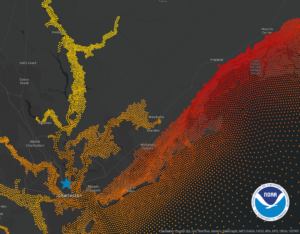
The CORA dataset delivers more than 40 years of modeled, historical water level and wave information every 500m – or roughly every quarter mile – along the US coastline. This long-term water level data was previously only available at NOAA tide gauge locations, which in some areas of the coast can be hundreds of miles apart.

CORA’s denser data resolution between tide gauges closes gaps in data coverage along the coast, ensuring more communities will have access to historical water level data to assess coastal flood risk.

“Historical coastal water level information is necessary to assess changing flood risks to communities and to predict the likelihood of flooding,” said Nicole LeBoeuf, director of NOS. “This new dataset will improve NOAA’s current flood-risk assessment tools and help scientists develop new coastal flood products and services for the nation.”

The new dataset provides the scientific and research community with access to previously unavailable historical data that can help advance research, machine learning and policymaking in a variety of sectors, such as coastal resource management and energy planning. CORA can be used by city planners, engineers, flood management professionals and decision makers to support their coastal flood planning efforts with more accessible historical information.

“CORA provides coastal communities with new insights into how their flood risk has changed over time,” said Analise Keeney, project lead and oceanographer at NOAA’s Center for Operational Oceanographic Products and Services (CO-OPS). “In Charleston, South Carolina, for example, CORA shows the full extent of the devastating inland flooding caused by Hurricane Hugo in 1989. Combined with NOAA’s long-term tide gauge data, the data enables more coastal communities to understand their past flood risks so they can better prepare and respond to future events.”

This image from CORA captures the full extent of maximum water levels in Charleston caused by Hurricane Hugo in 1989. Water level observations were only available from one location, a tide gauge represented by the blue star in the image. The CORA dataset fills gaps in water level data between tide stations. Each dot has a value. Red dots along the coastline show the storm’s extreme water levels at landfall. The orange and yellow dots show the full extent of inland flooding caused by the storm. By clicking here, you can view water level values in CORA’s interactive map. (Credit: NOAA CO-OPS, January 2025)

Improvements and advances to NOAA’s services

NOAA scientists will integrate CORA’s historical datasets into existing products, including the Sea Level Calculator and High Tide Flooding Outlooks, to provide context. They are also using CORA to prototype monthly high tide flooding predictions every 500m along the coast to provide more communities with timely information about their flood risks.

Further, NOAA’s Office of Water Prediction is collaborating with NOS to produce a multi-decade total water level simulation for the nation’s coastline using the CORA dataset combined with the National Water Model. Pairing these two datasets will help make coastal flood inundation mapping more robust.

NOAA plans to release Coastal Ocean Reanalysis datasets for the West Coast, Hawaii and Alaska by late 2026.

The CORA dataset spans from 1979 to 2022 and is available for public download through NOAA’s Open Data Dissemination platform in a variety of formats to support downstream applications. Additional information, maps, use cases and related resources are available on NOAA’s Tides and Currents website, as well as a NOAA technical report detailing the methodology.

CORA is a community-based modeling effort made possible through collaboration with the University of North Carolina’s Renaissance Computing Institute. Modeling validation was conducted by the University of Hawaii’s Sea Level Center.

The National Ocean Service is the nation’s source for tides, currents and coastal and Great Lakes water level information. Its scientific experts apply these data to a broad suite of products and services to ensure safe and efficient navigation, to support accurate mapping and charting, and to protect coastal economies and infrastructure from extreme weather.

In related news, the Department of Commerce and NOAA recently awarded US$1.95m in Inflation Reduction Act funding to support tribal resilience to drought. Click here to read the full story.

Previous ArticleEXCLUSIVE FEATURE: How are the latest early warning technologies protecting against devastating hurricanes?
Next Article Satellites can provide early warnings on glacier surges for high-mountain communities, University of Portsmouth and ICIMOD report

Read Similar Stories

Digital Applications

Tianjin University AI model turns street cameras into rainfall sensors

May 14, 20253 Mins Read
Climate Measurement

WMO releases State of the Climate in Africa 2024 report

May 12, 20255 Mins Read
Lightning Detection

Vaisala unveils helideck monitoring software for offshore operations

May 9, 20253 Mins Read
Latest News

EXCLUSIVE INTERVIEW: Ramla Qureshi, McMaster University’s Department of Civil Engineering

May 14, 2025

Tianjin University AI model turns street cameras into rainfall sensors

May 14, 2025

University of Exeter launches £5m, five-year project to model Sun’s atmosphere

May 13, 2025

Receive breaking stories and features in your inbox each week, for free


Enter your email address:


Supplier Spotlights
  • EWR Radar Systems
Latest Job Postings
  • Researcher/Engineer to support data-based weather forecasting (R2/RE2)

    • Barcelona
    • Barcelona Supercomputing Center - Centro Nacional de Supercomputación
    • Full Time
Getting in Touch
  • Contact Us / Advertise
  • Meet the Editors
  • Download Media Pack
  • Free Weekly E-Newsletter
Our Social Channels
  • Facebook
  • LinkedIn
© 2025 UKi Media & Events a division of UKIP Media & Events Ltd
  • Cookie Policy
  • Privacy Policy
  • Terms and Conditions
  • Notice and Takedown Policy

Type above and press Enter to search. Press Esc to cancel.

We use cookies on our website to give you the most relevant experience by remembering your preferences and repeat visits. By clicking “Accept”, you consent to the use of ALL the cookies.
Cookie settingsACCEPT
Manage consent

Privacy Overview

This website uses cookies to improve your experience while you navigate through the website. Out of these, the cookies that are categorized as necessary are stored on your browser as they are essential for the working of basic functionalities of the ...
Necessary
Always Enabled

Necessary cookies are absolutely essential for the website to function properly. These cookies ensure basic functionalities and security features of the website, anonymously.

CookieDurationDescription
cookielawinfo-checbox-analytics11 monthsThis cookie is set by GDPR Cookie Consent plugin. The cookie is used to store the user consent for the cookies in the category "Analytics".
cookielawinfo-checbox-functional11 monthsThe cookie is set by GDPR cookie consent to record the user consent for the cookies in the category "Functional".
cookielawinfo-checbox-others11 monthsThis cookie is set by GDPR Cookie Consent plugin. The cookie is used to store the user consent for the cookies in the category "Other.
cookielawinfo-checkbox-necessary11 monthsThis cookie is set by GDPR Cookie Consent plugin. The cookies is used to store the user consent for the cookies in the category "Necessary".
cookielawinfo-checkbox-performance11 monthsThis cookie is set by GDPR Cookie Consent plugin. The cookie is used to store the user consent for the cookies in the category "Performance".
viewed_cookie_policy11 monthsThe cookie is set by the GDPR Cookie Consent plugin and is used to store whether or not user has consented to the use of cookies. It does not store any personal data.

Functional

Functional cookies help to perform certain functionalities like sharing the content of the website on social media platforms, collect feedbacks, and other third-party features.

Performance

Performance cookies are used to understand and analyze the key performance indexes of the website which helps in delivering a better user experience for the visitors.

Analytics

Analytical cookies are used to understand how visitors interact with the website. These cookies help provide information on metrics the number of visitors, bounce rate, traffic source, etc.

Advertisement

Advertisement cookies are used to provide visitors with relevant ads and marketing campaigns. These cookies track visitors across websites and collect information to provide customized ads.

Others

Other uncategorized cookies are those that are being analyzed and have not been classified into a category as yet.

SAVE & ACCEPT
Powered by