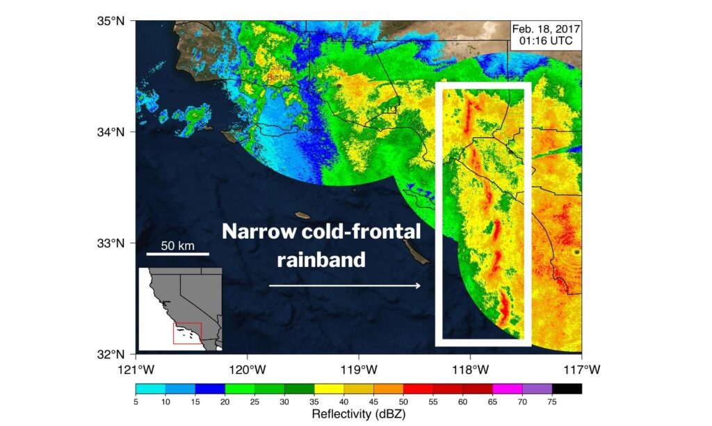
Researchers analyzing decades of winter storm data from southern California have created a catalog of rainbands to help improve predictions of localized, intense rainfall, which can lead to landslides and flash floods.
Known as narrow cold-frontal rainbands, the storms can stretch for tens to hundreds of kilometers in length but are only a few kilometers wide. They form along many of the world’s coasts, including both coasts of the USA.
Intense rain associated with narrow cold-frontal rainbands may last only a few minutes at a particular location, yet the rain can cause catastrophic flash flooding, debris flows and landslides, and can occur along with tornadoes and severe thunderstorms.
Predicting when and where theses events can occur is difficult, and evacuations can be issued over too large an area. Improving predictions of these atmospheric phenomena is important for avoiding evacuation fatigue and maintaining public trust in warning systems.
The new study analyzes three decades of radar and hazard-warning data from southern California, building a catalog of rainbands that will help scientists create storm prediction and tracking algorithms, with the eventual goal of “nowcasting” the storms: predicting their patterns and hazards just a few hours in advance.
Researchers found that from 1995 to 2020, 60% of these events resulted in at least one National Weather Service warning, and 15 of the 94 events led to 10 or more warnings as the bands swept across southern California. Some of the most intense events were associated with atmospheric rivers, and most hit in the region’s already-wet winter months of January through March.
Nina Oakley, an atmospheric scientist at the Scripps Institution of Oceanography and study co-author, said, “Our current predictive models struggle with location, timing and intensity of these events, and we need to improve that for evacuation warnings. If we issue evacuation warnings for what turns out not to be a high-impact event, you start to run into evacuation fatigue, where people might not trust the warnings in the future.”
Approximately 60% of the rainband events between 1995 and 2020 resulted in at least one warning from the National Weather Service and 15 exceptionally intense events resulted in 10 or more warnings of flash floods, tornadoes or debris flow and landslide risk as they swept across Southern California. “All but two of these intense rainband events were associated with atmospheric rivers, and two-thirds of our entire catalog were as well,” explained Marian de Orla-Barile, lead study author and geography Ph.D. student at the University of California, Santa Barbara.
High water vapor content in the atmosphere and intensifying low-pressure systems were also commonly associated with the rainbands.
Predicting disaster
The study’s catalog of narrow cold-frontal rainbands is an early, critical step in building an algorithm that can automatically identify and track areas of intense, potentially damaging rain. Such an algorithm is the heart of nowcasting, which aims to forecast rainfall within hours.
Because the rainbands can strengthen or weaken over time, especially as they encounter mountainous topography, pinpointing when and where they will produce the most intense rainfall and pose hazards is difficult. Not all narrow cold-frontal rainbands produce disastrous rainfall, nor do all pass over a populated area below a recent wildfire burn scar or landslide hazard area that would need to evacuate.
“With projected increases in wildfires as well as the projected intensification of short-duration rainfall, it’s likely that in a warming climate, there will be increased post-fire debris flow events, some of which could be associated with narrow cold-front rainbands,” said de Orla-Barile.
The study was published in the American Geophysical Union (AGU) journal Geophysical Research Letters, which publishes high-impact, short-format reports with immediate implications spanning all Earth and space sciences. To download a copy of the study, click here.


