Satellite data is helping emergency responders on the ground in the aftermath of a 6.4-magnitude earthquake in Puerto Rico.
NASA scientists are using data from the European Space Agency’s (ESA) Copernicus Sentinel-1A satellite to track where the quake and a number of powerful aftershocks may have caused damage.
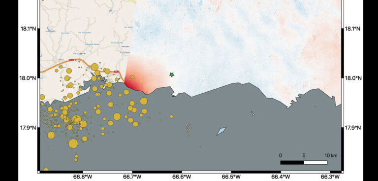
By comparing data from the satellite’s interferometric synthetic aperture radar (InSAR) from late December with data from January 9 – when the satellite flew over the island two days after the quake struck – scientists were able to note permanent changes to the ground surface resulting from the quake.
The data is being used by NASA to help US federal agencies such as the Federal Emergency Management Agency (FEMA) and local agencies on the ground in the disaster zone to identify the potentially worst-hit areas.
To help in the response and recovery effort NASA’s Earth Applied Sciences Disaster Program has been producing a number of GIS products for the emergency responders including power outage maps, damage maps and landslide maps.
In the resulting map produced by the US space agency, red denotes where the ground was changed, with darker shades corresponding to more significant displacement.
According to NASA the biggest displacement occurred west of the city of Ponce – identified on the map by the green star – not far from the earthquake’s epicenter off-shore.
The InSAR data recorded a 14cm ground shift – downward and slightly westward – at this point.
The quake’s epicenter and the site of the aftershocks was further to the west, slightly out of range of the satellite’s flyover route. As a result of this NASA scientists are awaiting data from another flyover by Sentinel-1A on January 14 that will take in the western portion of the island.


