Experts from the European Centre for Medium-Range Weather Forecasts (ECMWF) look at recent work that has been carried out to improve on some of the longstanding errors in convective precipitation.
Article by: Tobias Becker, postdoctoral researcher at the Max Planck Institute for Meteorology and visiting scientist at ECMWF; Peter Bechtold, principal scientist at ECMWF’s Physical Processes team; and Irina Sandu, ECMWF Physical Processes team leader
Human life depends on the accessibility of water in many ways, and is thus vulnerable to changes in the global water cycle. Global climate projections foresee that a warming climate will lead to less frequent precipitation events, increasing the likelihood of droughts and making precipitation more extreme when it does fall. In this context, it is becoming more pressing than ever to make better predictions of the global water cycle, and in particular of precipitation.
Precipitation can be generated by large-scale, typically frontal processes and by convection which occurs at smaller scales. Simulating the processes of convection remains a challenge for numerical weather prediction and climate models.
The challenges of modelling convective precipitation
Even though the representation of convection in numerical models has improved considerably in recent decades, convective precipitation still remains the most relevant cause of systematic errors in weather and climate models, according to a recent survey among global modelling centers.
Convection is complex and hard to model because it involves multiple processes, many of which take place at scales smaller than the model’s grid cell, so they need to be parametrized. The assumptions that have to be made when parametrizing convection explain many of the systematic errors in convective precipitation.
Climate projections and global weather forecasts at convective storm-resolving resolutions (2-4km), in which deep convective systems are at least partially resolved, are now becoming feasible and they provide a real opportunity to understand and improve on some of the longstanding errors in convective precipitation. Indeed, ECMWF aims to perform the first ensemble global weather forecasts in the world at a horizontal resolution of about 4-5 km by 2025.
During Becker’s three-month visit in the Physical Processes team at ECMWF in spring 2019, we demonstrated that such simulations do offer exciting possibilities to reduce some of the most persistent systematic biases in convective precipitation. We performed a first systematic comparison of global 4km resolution forecasts executed with and without parametrized deep convection with ECMWF’s Integrated Forecasting System (IFS).
Limitations of today’s convective parametrizations
Most systematic errors in convective precipitation arise from necessary assumptions in the convective parametrizations concerning:
- Triggering of convection.
- Mixing of the convective plumes with the environment.
- Estimation of the overall intensity of the convection as a function of the convective instability that arises from the large-scale lifting and the surface heating.
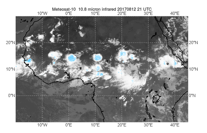
We focused our analysis of the IFS forecasts on tropical Africa, a region where large and long-lived squall lines form in late summer and the shortcomings of convective parametrizations become particularly obvious. We found that when the deep convection parametrization is used, the biases of the 4km forecasts resemble those of ECMWF’s 9km operational forecasts. Thus, precipitation is triggered too early and not maintained for long enough, mesoscale convective systems are too stationary and sometimes even propagate against the easterly low-level flow, contrary to what is observed.
 Figure 1: An example of mesoscale convective systems over tropical Africa
These systematic errors can be linked to the lack of memory in the parametrizations and an inadequate representation of the interaction between the convective-scale and large-scale flow. In contrast, when the deep convection parametrization is switched off (the “explicit” experiments discussed below), the mesoscale convective systems do propagate in a more realistic manner, but their intensity is overestimated compared to available rainfall data and convection becomes too localized, particularly over the tropical oceans.
Exciting prospects for modelling convection
We are now exploring how these remaining errors in convective precipitation at 4km resolution relate to interactions of deep convection with its environment.
Improving the inhibition of convection after a rain event
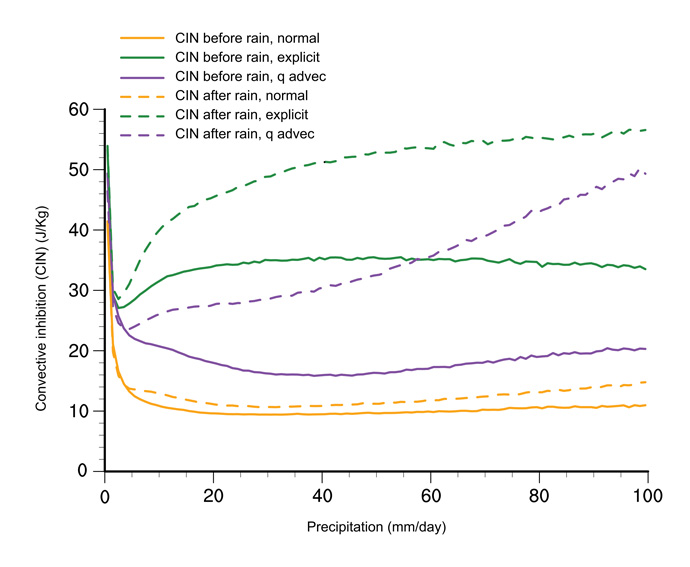
We have demonstrated, for example, that the lack of lower tropospheric drying, locally caused by convection-induced subsidence, together with too weak surface moistening and evaporative cooling, explains why the convective inhibition (CIN) after a rain event does not increase in the case of parametrized convection.
This is illustrated in Figure 2, where we have plotted the CIN before (solid lines) and after (dotted lines) rain events of given intensity from a large sample of intense mesoscale convective systems over tropical Africa during August 2016. In the parametrized run (orange lines) the CIN barely varies, while in the explicit runs (green lines) the CIN after a rain event increases markedly as a function of rain intensity, helping to move (favor) the convection in the direction of the flow.
 Figure 2: Convective inhibition (CIN) versus precipitation intensity (mm/day) in 4km resolution IFS forecasts with parametrized (normal) and without parametrized (explicit) deep convection. Solid and dashed lines refer to before and after a 3-hour rain event. Results are shown for tropical Africa, with 24 to 48 hours lead time of daily forecasts for August 2016. The baseline convection run is denoted as “normal” and the experimental version as “q advec” for total moisture advection
This inspired changes to the convection parametrization that aim to address this weakness, by including the total advection of moisture explicitly in the convective closure. This produced a marked increase of CIN after a rain event (purple lines in Figure 2). The CIN also increases with rain intensity as the convective induced subsidence and rain evaporation increases with increased convective activity (rainfall).
Improved westward propagation of tropical African convection
We have also examined the propagation of tropical African convective systems. While in the baseline parametrized run the convective systems are quasi-stationary and their intensity is about half that of the explicit run, in the experimental runs using the total moisture advection in the closure, there is a clear westward propagation which can also be verified visually on the rainfall and cloud fields (not shown).
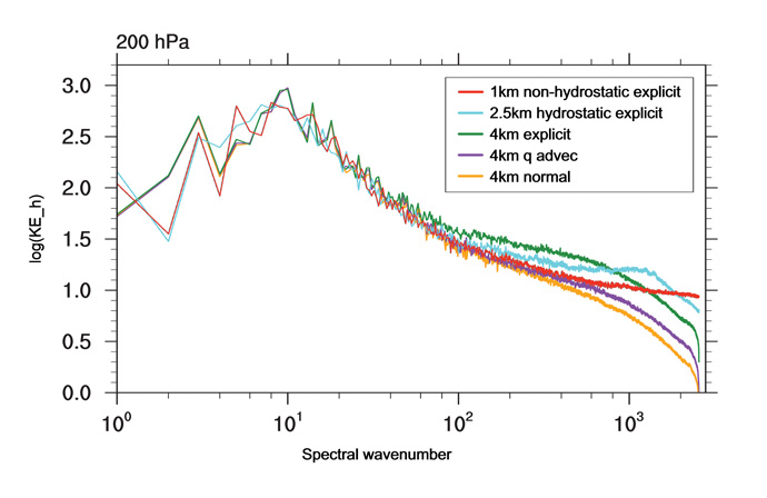
We also examined the overall global energetic signature of convection with the aid of global kinetic energy spectra as a function of the total wavenumber. As the effect of convective heating and divergent convective outflow maximizes in the upper troposphere, we show in Figure 3 kinetic energy spectra at 200 hPa. For better comparison we have also added the energy spectra for an explicit hydrostatic simulation at 2.5km horizontal resolution and a non-hydrostatic explicit simulation at 1km with the ECMWF IFS as provided by Nils Wedi.
 Figure 3: Kinetic energy spectra as a function of the total wavenumber for the 4 km baseline run with (normal, orange) and without parametrized convection (explicit, green), the experimental version with revised deep convection (q advec, purple), as well as a hydrostatic explicit simulation at 2.5 km (cyan) and a non-hydrostatic simulation at 1 km (red) as provided by Nils Wedi
Comparing the explicit (green) and baseline (orange) parametrized 4km runs, we notice for wavenumbers >100, that is for scales <200–300km, a much higher kinetic energy in the explicit simulation of up to a factor of three (note the log scale).
However, comparing all the explicit simulations at resolutions of 4, 2.5 and 1km, we see that the kinetic energy in the mesoscales actually decreases with increasing model resolution. Assuming that convective mixing becomes better resolved with increasing resolution, we conclude that the explicit 4km run strongly overestimates the kinetic energy (and the convective activity which is independently verified with the aid of precipitation data). The overall encouraging result in Figure 3 is that if we take the 1km explicit run (red) as a benchmark, the 4km simulation with the revised convection parametrization (purple) is more active than the baseline simulation and the spectra closely follow the benchmark 1km simulation for scales >20-40km. Note that only scales of 4-8 times the grid resolution can be resolved.
This leaves us with more encouraging work to do for the future 4km resolution update, likely mitigating features of parametrized and explicit convective overturning. New observational field campaigns like the recent OTREC campaign will also be helpful to improve the representation of organized convection (Figure 4).
 Figure 4: The OTREC field campaign is helping to gather detailed observations of tropical convection. The photo shows Peter Bechtold (left) and Zeljka Fuchs (principal investigator of OTREC)
This article is courtesy of ECMWF.


